Sebastian Muenster. Basel, 1540/1572. 265 x 345 mm. [10-1/2 x 13-1/2 in.]
First appearing in 1540, this wood block print is the first map of much significance dedicated to the Western Hemisphere, clearly showing it as a separate land mass, with continuity between the northern and southern continents. The Yucatan is shown as an island, and Japan (Zipangri) is located not very far off the west coast of North America. Mare Pacificum appears for the first time on a printed map, with a depiction of Magellan’s ship in it. Exploration had been more focused on South America at the time this map was first issued, which helps account for the inaccurate shape of the North American continent as seen here. This map also contributed to the permanency of labeling the two continents ‘America’, as it was reissued numerous times for over sixty years. This specimen is the thirteenth state, from a Latin edition of Muenster’s Cosmography. ex Robert H. Power Collection. SOLD
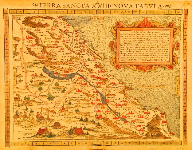
Sebastian Muenster. Basel, 1552. 290 x 375 mm. [11-1/2 x 14-3/4 in.]
North is situated at the right of this wood block print of the Holy Land. In the cartouche is a list of placenames in their various forms, both ancient and contemporary with the map. SOLD
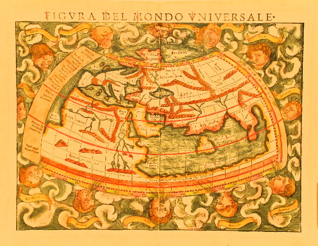
Sebastian Muenster. Basel, 1558. 255 x 345 mm. [10 x 13-5/8 in.]
This beautiful depiction of the Old World from Muenster’s Cosmographie is a wood block print. Twelve windheads surround the map which is based on Ptolemy. $2,400.
Girolamo Ruscelli. Venice, 1561. 190 x 250 mm. [7-1/2 x 9-3/4 in.]
Based on Gastaldi’s 1548 map bearing the same title, this enlarged version corrects the error that showed the Yucatan Peninsula as an island, although the copperplate for this map originally was engraved showing it as an island - evidence of the corrections can be seen here. Despite the correction, this is considered the first state. Mexico city is depicted by a tiny image of a city in a body of water. The Mississippi River is still shown with its early name R: de Spirito Santo [River of the Sacred Spirit], and the area of present day Baja California is correctly shown as a peninsula as was the custom in the 16th century, proving that the practice of depicting it as an island was a latter day error propagated by Briggs and Goos circa 1624. $1,400.
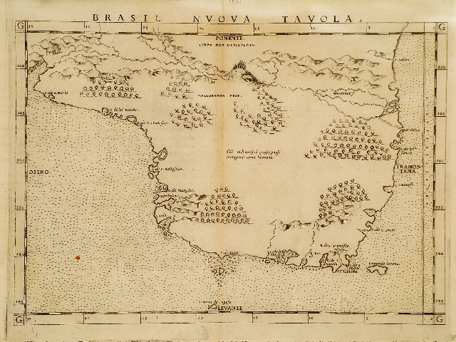
Girolamo Ruscelli. Venice, 1561. 180 x 255 mm. [7-1/8 x 10-1/8 in.]
One of the earliest printed maps focusing on Brazil, this copperplate engraving with rulers along the borders depicts mountains, forests and rivers. Considerable detail is given to coastal islands. $400.
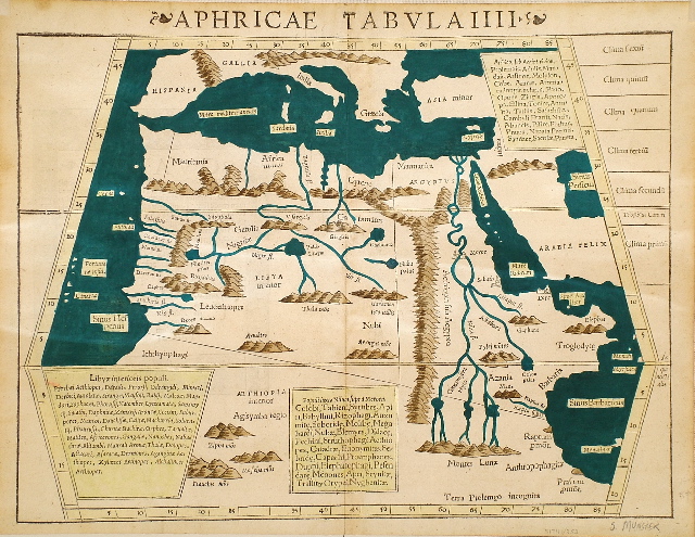
Sebastian Muenster. Basel, 1565. 265 x 345 mm. [10-1/2 x 13-1/2 in.]
Wood block engraving of the upper half of the African continent, emphasizing the rivers, seas, and mountains, includes the surrounding regions of Hispania, Gallia, Italia, Greacia, Asia Minor and Arabia. Three Latin textual insets list the peoples (populi) of Libya, those near the Nile, and those of Ethiopia below the Egyptian state (civitat). $1,200.
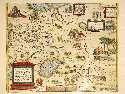
Abraham Ortelius. Antwerp, 1570. 355 x 445 mm. [13-7/8 x 17-1/2 in.]
The title cartouche states in the Latin form (as was customary in the period) that the author is Englishman Anthony Jenkinson, edited in London in the year 1562 [Auctore Antonio Ienkensono Anglo, edita Londini Anno 1562...] Highly picturesque and colorful, the map portrays many cultural and social characteristics of the region in numerous vignettes engraved on copperplate, with Latin text descriptions. SOLD
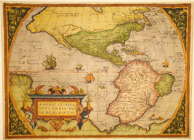
Abraham Ortelius. Antwerp, 1570/1571. 365 x 505 mm. [14-3/8 x 19-7/8 in.]
Printed in Theatrum Orbis Terrarum which is regarded as the first modern world atlas, this copperplate engraving proved to be a keystone map for its representation of the Western Hemisphere, despite the enormous bulge erroneously shown on the southwest coast of South America. The coastline error was removed in the third plate which was engraved in 1587. Although Gerard Mercator was the first cartographer to actually apply the term ‘atlas’ to a collection of maps, Ortelius’ Theatrum was the first publication to include a world map along with an entire collection of maps relating to each other, with the intent to give a complete picture of the world. Settlements of the New World are shown in greater detail than before, although there are no new placenames. This specimen is from plate one, state two, of the 1571 Latin edition. $4,200.
Braun and Hogenberg. Cologne, 1573 [or later to 1598]. 360 x 480 mm. [14-1/4 x 19 in.]
Colorful city view of the ancient Egyptian city of Alexandria from Braun and Hogenberg’s celebrated Civitates Orbis Terrarum, the first atlas of town and city views encompassing the whole world. Engraved on copperplate, the view shows extensive details of the buildings and layout of the city which was founded as the new Greek capital of Egypt by Alexander the Great in 331 BC, immediately after his conquest of Egypt in 332 BC. With south situated at the top, the Mediterranean is shown at the bottom, and from the western delta of the Nile River canals flow through the city and empty into the sea. During the third century BC, Egypt was ruled by the Ptolemies under Greek control, and became the richest of the Hellenistic powers. Their wealth turned Alexandria into the world’s greatest city, where they built the great Museum [meaning ‘for the Muses’], which housed the royal Library. Geographical knowledge to be found in the Library was summed up around 200 BC by Eratosthenes, the Museum librarian, who calculated the circumference of the earth at approximately 25,000 to 25,200 miles, amazingly close to the actual circumference, which is about 24,900 miles. By 25 BC, with Alexandria now under Roman rule, the Museum Library had grown to 490,000 volumes, included works in Greek, Egyptian and Hebrew, and may have housed Aristotle’s library which was believed to have been sold to Philadelphus, the Ptolemy ruler who succeeded Ptolemy Soter, founder of the Museum. It was in this greatest of all libraries in 25 BC that the wealthy Greek scholar Strabo of Amasia began five years study in preparation for his Geography, in which modern knowledge of the history of cartography truly begins, since there are so few earlier maps or geographical writings extant. SOLD
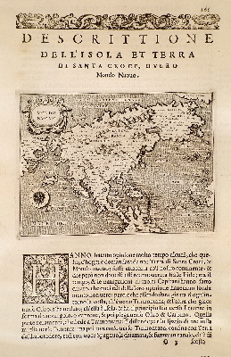
Tomaso Porcacchi. Venice, 1576. 255 x 150 mm. [10 x 6 in.]
Copperplate engraving executed by Girolamo Porro of Padua, with the map centered in a page of Italian text, from Porcacchi’s L’Isole piu Famose del Mondo, based on the 1565 map by Paolo Forlani. SOLD
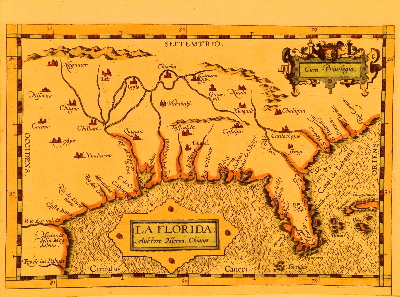
Abraham Ortelius. Antwerp, 1584. 150 x 225 mm. [6 x 8-7/8 in.] Cropped from a larger map which included maps of Peruviae and Guastecan.
The earliest printed map devoted to the southeast region of North America, La Florida was authored by Hieronymus de Chiaves, Cosmographer Royal to Philip II of Spain. Although many of the coastal placenames on this copperplate engraving are seen on other maps of the period, many of the names in the interior region appear here for the first time, and are similar to those found on Mapa del Golfo y costa de la Nueva Espana, a manuscript attributed to Alonso de Santa Cruz, circa 1544, which documented the 1539-43 expedition of Hernando de Soto. The influence of Ortelius’ La Florida was extensive. Subsequent regional maps for which it was used as source material include Florida et Apalche by Cornelis van Wytfliet (1597), Florida et Apalche by Johannes Metellus (1598), Florida et Regiones Vicinae by Johannes de Laet (1630), and even later, La Floride by Nicolas Sanson (1657). SOLD
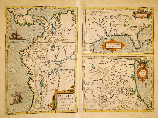
Abraham Ortelius. Antwerp, 1584/1603. 340 x 465 mm. [13-1/2 x 18-3/8 in.]
The earliest printed map devoted to the southeast region of North America, La Florida was authored by Hieronymus de Chiaves, Cosmographer Royal to Philip II of Spain. Although many of the coastal placenames on this copperplate engraving are seen on other maps of the period, many of the names in the interior region appear here for the first time, and are similar to those found on Mapa del Golfo y Costa de la Nueva Espana, a manuscript attributed to Alonso de Santa Cruz, circa 1544, which documented the 1539-43 expedition of Hernando de Soto. The influence of Ortelius’ La Florida was extensive. Subsequent regional maps for which it was used as source material include Florida et Apalche by Cornelis van Wytfliet (1597), Florida et Apalche by Johannes Metellus (1598), Florida et Regiones Vicinae by Johannes de Laet (1630), and even later, La Floride by Nicolas Sanson (1657). Peruviae... presents great detail of the rivers and mountains from the Isthmus of Panama to the Tropic of Capricorn, including numerous Inca tribes and familiar placenames such as Panama, Cartagena, Maracaibo, Bogota, Popayan, Quito, Rio de las Amazones, and Cusco. Guastecan extends the coastline southward from the bottom of La Florida, encompassing much of the east coast of present day Mexico. $2,200.
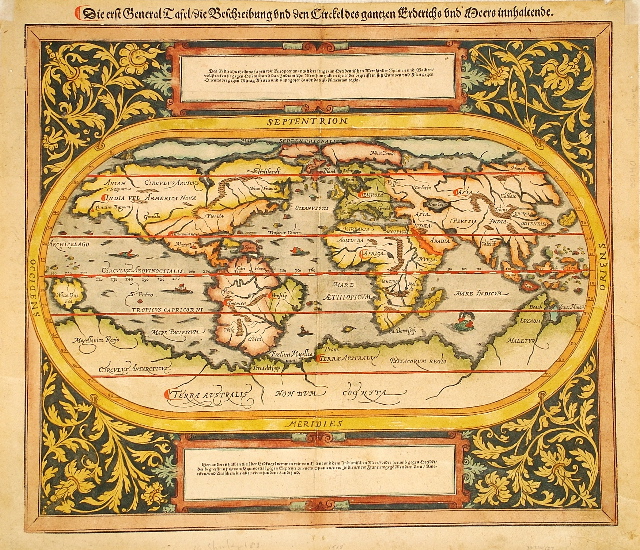
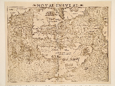
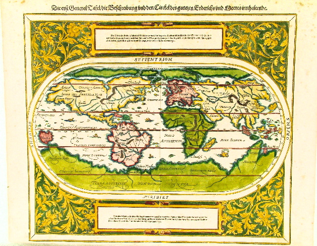
Sebastian Muenster. Basel, circa 1588. 325 x 365 mm. [12-3/4 x 14-3/8 in.]
Striking early depiction of the world done in wood block print devotes half the area to the New World, with German title printed above the border, and Latin nomenclature. Clearly based on the 1564 copperplate map Typus Orbis Terrarum by Ortelius, it shows the fabled Northwest Passage above the North American continent, believed to link the north Atlantic and the north Pacific Oceans. At the bottom a huge land mass intended to encompass Antarctica is labeled Terra Australis Nondum Cognita [Southern Land Not Yet Known]. $3,200.
Sebastian Muenster. Basel, circa 1588. 325 x 365 mm. [12-3/4 x 14-3/8 in.]
Striking early depiction of the world done in woodcut devotes half the area to the New World, with German title printed above the border, and Latin nomenclature. Clearly based on the 1564 copperplate map Typus Orbis Terrarum by Ortelius, it shows the fabled Northwest Passage above the North American continent, believed to link the north Atlantic and the north Pacific Oceans. At the bottom a huge land mass intended to encompass Antarctica is labeled Terra Australis Nondum Cognita [Southern Land Not Yet Known]. SOLD
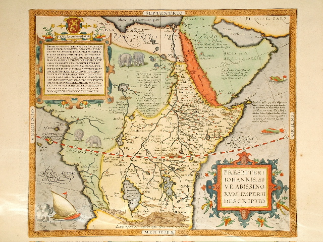
Abraham Ortelius. Antwerp, circa 1588. 375 x 440 mm. [14-3/4 x 17-1/4 in.]
Beautiful and colorful map relating the legend of Prester John, rumored in the 12th century to be a Christian emperor who had founded a kingdom named Kara Khitai somewhere in Asia. Both Pope Alexander III and Pope Innocent IV tried to make contact with the mythical ruler in the hopes of forging an alliance to strengthen the Christian world during the Crusades and after. Various maps located the mythical kingdom in lower Scythia in Europe, in part of India, in Central Asia, and finally in Abyssinia in Africa, as on this example by Ortelius which was engraved on copperplate more than 400 years after the birth of the myth. A cartouche in the upper left of the map presents the coat of arms and titles of Presbyter Johannes, tracing his ancestral lineage back to King David. Prester John had supposedly written a letter describing how Gog and Magog, with “twenty-two nations of evil men”, would overrun the Christian world with the coming of the Antichrist. Belief in this apocalypse was so strong that even Roger Bacon believed studies should be made to determine when and where the invasions would begin. $2,300.
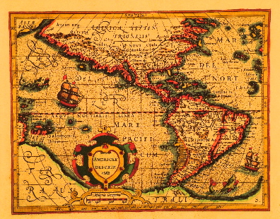
Gerhard Mercator / Joducus Hondius. Amsterdam, 1588/1607. 150 x 195 mm. [5-7/8 x 7-5/8 in.]
Mercator’s copperplates were bought by Hondius, who was actually the first to issue many of them, as Mercator had died before completing the issue of his atlas. This map is Mercator’s work but was issued by Hondius. The South American southwest coastline no longer shows the excessive land mass that appeared on the earlier versions of this map of the Western Hemisphere. Philip Burden suggests that the date ‘1588’ appearing in the cartouche was later added in manuscript, since there is no recorded state of this map with the date in the plate. SOLD
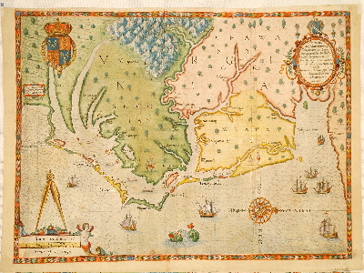
John White / Theodore De Bry. Frankfurt, 1590. 305 x 415 mm. [12 x 16-1/4 in.]
The second state of the first separate map of the first English colony in America, named Virginia in honor of Queen Elizabeth I. Printed by Theodore De Bry in Part I of his Grand Voyages which included an illustrated edition of Thomas Hariot’s A Briefe and True Report of the New Found Land of Virginia, it was the most accurate and detailed 16th century map of any part of North America, and its influence was felt for nearly a century. Largely encompassing the coastal area of present day North Carolina, the names Hatorask [Hatteras] and Chesepiooc [Chesapeake] make their first printed appearance. De Bry’s copperplate engraving was based on manuscripts by John White, an artist who accompanied an exploratory party to help document the search for a site for colonization, dispatched by Sir Walter Raleigh in 1584-1587. White quickly rose to governor of the settlement on Roanoke Island. While he was on a lengthy return to England, the settlers disappeared without a trace, including his daughter and granddaughter Virginia Dare, the first English child born in the New World. This vanished settlement is now known as the Lost Colony. SOLD
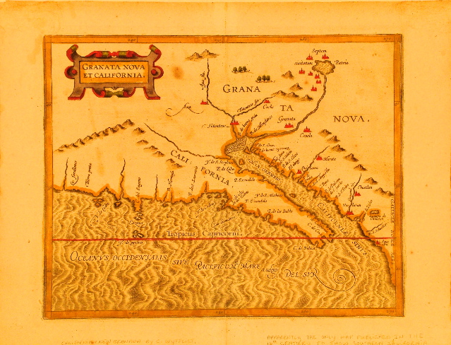
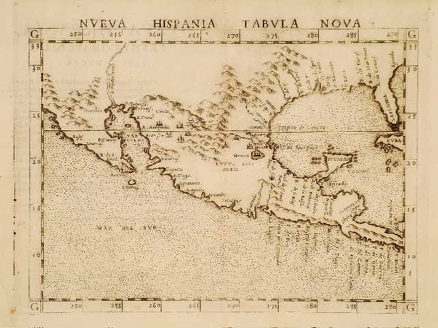
Cornelis van Wytfliet. Louvain, 1597. 225 x 290 mm. [8-7/8 x 11-3/8 in.]
Included in Wytfliet’s Descriptionis Ptolemaicae Augmentum, which was the first atlas focusing exclusively on America, Granata Nova et California is also the first printed map to focus on the region of southern California. The copperplate engraving was cartographically derived from contemporary authorities such as Abraham Ortelius. SOLD
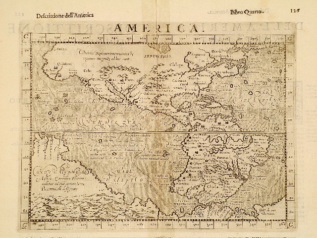
Giovanni Botero. Venice, 1598. 190 x 255 mm. [7-1/2 x 10 in.]
Second state of the 1595 map which appeared in Botero’s popular Le Relationi Universali. Based on and almost identical to the 1582 map by Giovanni d’Anania, this copperplate engraving of the Western Hemisphere was also included in several other editions of Botero, who was Secretary of the Duke of Savoy. A reduced version was used in late 16th and early 17th century Ptolemaic geographies by Magini and Rosaccio. $1,200.